Scenic Coastal Driving & Photography in Gangwon-do: 2024/2025 Guide

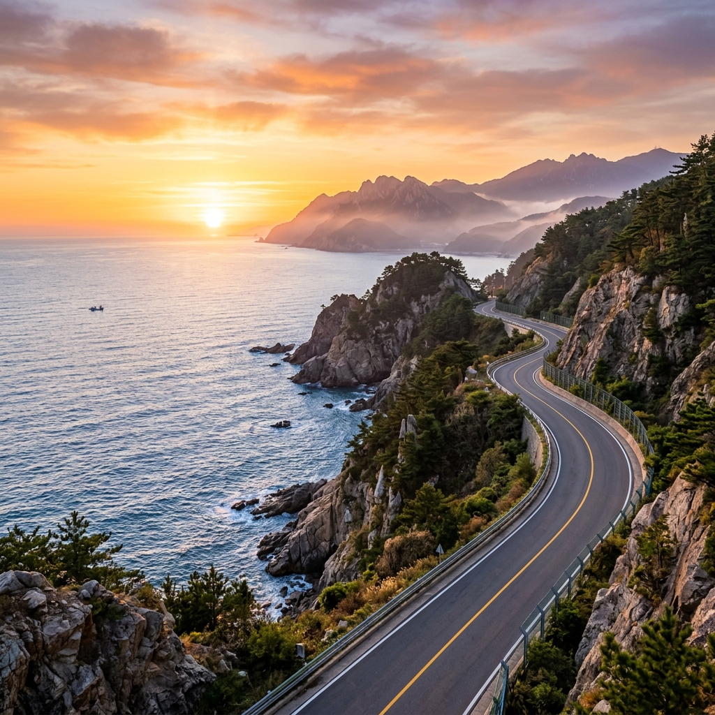
There are roads in Korea that feel less like infrastructure and more like an invitation. Gangwon-do's east coast is full of them — two-lane strips of asphalt that cling to sea cliffs, dip through fishing villages, and occasionally bring you so close to the water that salt spray finds its way through your cracked window. Whether you're chasing the first light at Chuam Candle Rock or threading through coastal curves with a camera bag riding shotgun, this stretch of coastline delivers the kind of driving and photography that stays with you long after you've returned the rental keys.
Gangwon-do's eastern seaboard runs roughly 200 kilometers from Sokcho in the north to Samcheok in the south, tracing a corridor where the Taebaek Mountains drop sharply into the East Sea. National Route 7 follows this corridor almost entirely, threading through resort towns, tidal flats, and exposed headlands. What makes it exceptional for road trippers and photographers isn't just the scenery — it's the density of compelling stops packed into a manageable distance. You can drive the whole coast in a single day, but you'll find yourself pulling over every twenty minutes. Plan for at least three days.
The Best Coastal Routes in Gangwon-do
For anyone approaching this region for the first time, understanding the geography separates a frustrating scramble from a fluid journey. The coast isn't one uniform thing — it shifts from rocky sea cliffs around Sokcho and Yangyang to long sandy stretches near Gangneung, then back to dramatic geological formations as you head south toward Donghae and Samcheok. Knowing which section suits your goals saves hours of backtracking.
The most efficient approach is to drive south from Sokcho, following the coast continuously. This direction keeps the ocean on your left the entire time, meaning you're always close to viewpoints without crossing lanes. Allow roughly four to five hours of pure driving time for the full run, then add stops liberally.
Heonhwa-ro — Korea's Closest Road to the Sea
Heonhwa-ro is the single most discussed piece of road on Gangwon-do's coast, and it earns that reputation. Located south of Jeongdongjin and accessible from National Route 7, this short coastal spur — roughly two kilometers — runs so close to the water that waves regularly lap the guardrail during high tide and heavy swells. On calm days the road surface is damp from spray; on rougher days it can be temporarily closed.
The experience of driving it is genuinely unique in South Korea. Most coastal roads maintain at least a few meters of buffer between asphalt and sea. Heonhwa-ro eliminates that buffer almost entirely. You drive between a low stone wall and the ocean, with the cliff face rising on your inland side. It's a one-way road for most of its length, which means you won't have oncoming traffic complicating what is already a focus-intensive stretch.
For photographers, Heonhwa-ro is best approached on foot after parking at either end. Walk back along the road during the late afternoon and use a telephoto lens to compress the sea cliffs with the road in frame. A 70-200mm lens creates the dramatic "road pinched between rock and water" shot that circulates widely on Korean travel photography accounts. Bring a polarizing filter to manage reflections from the wet road surface.
Getting there: From Gangneung city center, take National Route 7 south for approximately 12 kilometers toward Jeongdongjin. The Heonhwa-ro turnoff is signed. If you overshoot, the Jeongdongjin train station is a useful landmark — Heonhwa-ro begins about 1.5 kilometers north of the station on the coastal side.
National Route 7 — The Full Gangwon Coastal Drive
National Route 7 is the spine of east coast Korea, running from Busan in the south all the way to the Demilitarized Zone in the north. The Gangwon-do section, from the Gyeonggi-do border near Goseong down through Samcheok, covers roughly 200 kilometers and constitutes the most scenic stretch of the entire highway.
The northern segment, between Goseong and Sokcho, passes through the buffer zone near the DMZ and feels notably quieter than the sections further south. Traffic thins, the road narrows, and the mountains press closer to the coast. This section rewards early departures and weekday driving — on summer weekends it can clog with domestic tourists headed to Sokcho's beaches.
The central Gangneung segment threads through the city's beach district, where surf cafes and pension houses line both sides of the road. Gyeongpo Beach is the easiest place to access from the highway, with large parking areas and beach access. Further south, the road curves around Jeongdongjin — a town famous for a beach so close to a rail station that you can step off the train and onto the sand in under two minutes. The iconic Hourglass Park sits on a bluff here, worth a brief stop for views back north along the coastline.
South of Donghae, the Route 7 corridor passes through the Samcheok Coast, where the geology changes dramatically. The limestone karst landscape that creates Samcheok's famous caves also generates bizarre coastal formations — stacked rock columns, sea arches, and tide pools carved into platforms of grey limestone. This section is less visited than Gangneung or Sokcho but arguably more interesting photographically.
Samcheok Coastal Road and the Southern Approach
The Samcheok section deserves its own planning slot. The stretch from Donghae south through Samcheok toward Chuam sits within a UNESCO-recognized geopark and features geological diversity that photographers rarely find concentrated in such a small area. The Haesindang Park is here, as are the Hwanseongul Caves further inland — but the coastal road itself is the main event.
Drive slowly through this section. The road hairpins around several headlands, and each curve reveals a different configuration of sea stacks, arches, and layered cliff faces. Pull-outs are frequent and informal — other drivers will give you cues about where to stop. A walking path connects several of the major viewpoints and is accessible even without hiking gear.
Iconic Photography Spots Along the Coast
The Gangwon-do coast has been photographed extensively, but most images cluster around four or five canonical locations. Knowing what makes each one work — and when to arrive — separates competent travel photos from images worth printing.
Chuam Candle Rock — The Definitive East Coast Sunrise
The Chuam Candle Rock (추암 촛대바위) sits at the southern edge of Donghae city and is one of the most recognized natural landmarks in Korea. The formation is a single sea stack approximately 15 meters tall, sculpted by erosion into a shape that — on certain days, in certain light — genuinely resembles a candle. It sits in a bay surrounded by smaller rock formations, tide pools, and a pebble beach.
Sunrise here is legitimately spectacular. The rock faces roughly east-northeast, which means the sun rises almost directly behind it during the equinoxes. Around the spring and autumn equinoxes, photographers routinely line up along the beach before 5 a.m. to capture the moment the sun crests the horizon directly above the stack. Outside those windows, the sun rises at a slight offset, which actually creates more interesting compositional options for most photographers — the rock is side-lit rather than backlit, revealing texture in the volcanic basalt.
Practical details: The parking lot adjacent to Chuam Beach opens early but can fill quickly on clear-sky mornings. Arrive 45 minutes before sunrise at minimum. The beach access path from the lot to the rock takes about eight minutes on foot. Bring a headlamp for the walk down. Admission to the area is free.
For gear, a 16-35mm wide-angle lens captures the rock in context with the surrounding bay. A 50mm or 85mm isolates the stack against the sky more dramatically. Bring both if you have them. A 6-stop ND filter is sufficient for long-exposure work during the half-hour after sunrise when light levels are rising quickly.
Seobin-dong Rocky Outcrop — Sokcho's Hidden Texture
North of Sokcho proper, the Seobin-dong coastline offers a different photographic register from the landmark-focused shooting at Chuam. Here the appeal is texture and pattern — the rock formations are conglomerate layers rather than volcanic pillars, creating horizontal banding that photographs beautifully in raking low-angle light.
The area is less visited than Sokcho's Cheoksan or the more famous Ulsanbawi rock in nearby Seoraksan, which means you have more freedom to move around and find angles without competing with other photographers. The tide pools here are among the most accessible on the coast and support interesting macro photography when the light is flat and unsuitable for landscapes.
Access is straightforward: park at the Seobin-dong Beach lot (free, signposted from the coastal road) and walk north along the beach. The interesting rock formations begin after about 300 meters. Continue walking for another 500 meters to reach the more dramatic sections. The entire walkable section is roughly 1.5 kilometers.
Best light: late afternoon in any season, when the sun is low enough to rake across the horizontal banding in the cliff faces. Summer mornings work if you're coming from Sokcho and want to combine this stop with an early breakfast at one of the fishing village restaurants in town.
Ocean-View Cafes — Shooting Through Glass
The Gangneung and Yangyang coastlines have developed an extraordinary concentration of architecturally interesting cafes positioned for maximum ocean exposure. For travel and lifestyle photographers, these spaces offer controlled light (through large windows), willing subjects (other travelers), and dramatic backdrops (the open sea) in combination.
The most photographed category is the "glass box" cafe — a building with floor-to-ceiling windows on the ocean side, creating a natural frame-within-frame for portrait work. Light inside these spaces is typically soft and diffuse during cloudy conditions, making them excellent for portraiture when outdoor landscape shooting is frustrated by flat light.
For interior photography, arrive outside peak hours (11 a.m. to 2 p.m. on weekends) when the cafes are quieter and less crowded in the frame. Ask permission before photographing other patrons. Many cafes in this area are Instagram-native businesses that actively welcome photography, but some prefer discretion.
The Jumunjin area (between Gangneung and Yangyang) has become particularly dense with these cafes and offers a useful stop for a coffee and a photography break between outdoor shoots. The local specialty is a soft-serve ice cream made with fresh milk from local dairy farms — worth eating regardless of photographic merit.
Practical Driving Tips for Gangwon-do's Coast
Getting the most from this drive requires some logistical preparation that isn't obvious from travel brochures. Korean coastal roads behave differently depending on the season and day of week, and the photography goals add additional constraints around timing.
Rental Car Essentials
Foreign visitors driving in South Korea require an International Driving Permit alongside their home country license. The IDP must be from your home country — South Korea accepts IDPs under the 1968 Vienna Convention. Check your country's specific IDP issuing authority; in the United States, the AAA and AATA issue them. Processing takes five to ten business days, so apply before your trip.
Rental desks at Incheon Airport and in Seoul city include the major international brands and several Korean-specific operators like Lotte Rent-a-Car and SK Rent-a-Car. Korean operators tend to be cheaper and have better app interfaces but may have less English customer support if something goes wrong. For a coastal drive with a camera setup, consider whether you need additional cargo space — a compact sedan is sufficient for one photographer but tight for two with full kit.
Collision Damage Waiver (CDW) is standard but check whether your credit card includes rental car coverage — some premium travel cards do, which can save you ₩15,000–₩25,000 per day.
Navigation: Korean GPS devices typically underperform on coastal roads because they lag behind road changes. Use Naver Map or Kakao Map on a mounted smartphone instead. Both apps include real-time traffic, construction alerts, and toll information. Naver Map has slightly better English-language interface. Download offline maps before you leave cellular coverage in mountain sections.
EV Charging Considerations
South Korea has expanded its EV charging network considerably, and Gangwon-do's coastal cities — Sokcho, Gangneung, Donghae, and Samcheok — all have public fast chargers. The challenge for a photography-focused coastal drive is that your stops tend to be short and scattered rather than concentrated in one location, making it harder to schedule a proper charging session.
The most practical approach for EV drivers is to charge fully in Gangneung or Sokcho at the start of each day's driving section. Both cities have DC fast chargers (50kW and 100kW) at major parking lots and near rail stations. Use Naver Map's charging station layer to locate them. Charge to 80% rather than 100% to reduce charging time, and plan a midday stop in Donghae if you're doing the full south run.
Traffic and Seasonal Timing
Gangwon-do's coast is a domestic holiday destination, and Korean public holidays transform the roads dramatically. Chuseok (autumn harvest festival) and Korean New Year (Seollal) create multi-day gridlock on all routes into and out of Gangwon-do, including National Route 7. Avoid these periods entirely unless you're already positioned in the region before the holiday window opens.
Peak summer (late July to late August) brings beach season crowds to Gangneung and Sokcho. Route 7 through the beach districts operates near capacity on weekends. Mornings before 8 a.m. are the exception — if you're rising for sunrise photography anyway, you'll avoid the worst of it.
The best windows for both driving and photography are late spring (May to early June) and mid-autumn (mid-September to late October). Weather is more predictable, crowds thin out noticeably, and the light quality improves significantly. Autumn in particular adds coastal forest color to the landscape photography palette — the mountains pressing against the coast turn rust and gold while the sea remains a deep blue.
Winter visits (December to February) offer the most dramatic atmospheric conditions: ice formations on sea cliffs, morning mist sitting low over the water, and almost no other tourists. It requires cold weather preparation and some flexibility around road closures, but yields unique images unavailable in other seasons.
Pro Photography Techniques for Coastal Work
Understanding the technical demands of coastal photography separates frustrating sessions from productive ones. The east coast environment presents specific challenges: high contrast between bright sky and dark water, moving subjects (waves) requiring careful shutter speed decisions, and rapidly changing light during the golden hours when most of the interesting shooting happens.
Sunrise Shooting Workflow
A successful sunrise session at Chuam or Heonhwa-ro requires a pre-dawn arrival and a structured approach to the hour of best light. The light window is narrow — roughly 20 minutes before and 30 minutes after sunrise — and conditions change faster than most beginners expect.
The night before, research the exact sunrise time for your location (use a dedicated app like PhotoPills or The Photographer's Ephemeris rather than a generic weather app). Identify your primary composition and a backup. Drive to the location the previous afternoon if possible to walk the terrain in daylight — this lets you identify footing, locate outlets for power cables if shooting video, and choose your tripod position.
At the location: set up 45 minutes early. In the dark, use your phone's flashlight to check your tripod legs on uneven surfaces. Set your focus using live view, targeting a bright star or the distant horizon with focus assistance. Start with a base exposure: ISO 400, f/8, check the histogram at 30 seconds before sunrise. Adjust from there as light grows.
Bracketing: Take three exposures — one for the sky, one for the sea, one for the rocks — and blend in post-processing. Lightroom's HDR merge handles this cleanly for static elements. Waves require manual blending or a single "correct" exposure that accepts some compromise in highlights or shadows.
Long Exposure and ND Filter Technique
Long-exposure ocean photography with ND filters transforms the visual character of the sea. Crashing waves become smooth and misty; the inherent chaos of the water surface is averaged into a flowing form that communicates movement without frozen spray.
The basic technique is straightforward: mount camera on tripod, attach ND filter, extend shutter speed until the wave motion blurs. The specific duration determines the effect: 1-4 seconds produces a silky flow while retaining some wave structure; 15-30 seconds creates the dense mist effect most people associate with fine-art coastal photography; 1-3 minutes produces near-total dissolution of the water surface, leaving only the rocks and sky as sharp elements.
For Gangwon-do's coast specifically, the 15-30 second range tends to work best. The wave energy here is moderate — not Pacific-level surf, but not the flat conditions of the southern coast either. Waves arrive with a rhythm that benefits from the medium duration: you capture several complete wave cycles, creating a coherent blend rather than a single wave frozen in mid-blast.
Filter stacking: if you're shooting during golden hour rather than midday, you may not need a 10-stop filter. A 3-stop ND combined with a 3-stop graduated ND (dark on top, clear on bottom) gives you control over both exposure duration and sky-to-sea balance simultaneously. This two-filter approach is more versatile than a single 10-stop ND across changing light conditions.
Avoiding camera shake: even with a tripod, mirror vibration in DSLRs and shutter shock in mirrorless cameras can reduce sharpness on long exposures. Use a remote shutter release or the camera's built-in timer delay (2-second delay is sufficient for exposure durations over 10 seconds). If your camera has an electronic shutter mode, use it — it eliminates mechanical vibration entirely.
Combining the Drive with Gangwon-do's Wider Attractions
A coastal photography trip pairs naturally with the inland attractions that make Gangwon-do one of Korea's most diverse travel regions. For those who've already explored Seoraksan National Park's granite peaks or the historic streetscapes of Gangneung Hanok Village, the coastal drive adds a seaward counterpart to the mountain experience.
The Gangneung Coffee Culture scene has developed into a significant draw independent of the natural landscape — the city consistently ranks among Korea's top coffee destinations, with a concentration of roasters and specialty cafes in the Aenggangjeong district near the beach. Building a coffee route into your driving plan adds a distinctly local cultural layer to what might otherwise be purely landscape-focused travel.
For photographers specifically, Seoraksan's granite formations offer a completely different technical challenge from the coastal work — telephoto compression of mountain ridges, misty morning fog over valleys, and autumn color on steep terrain. The two photographic environments complement each other well in a single Gangwon-do trip, and the drive between Sokcho (Seoraksan's gateway) and the coastal photography spots is under 30 minutes.
The hidden gems of Gangwon-do including Sokcho and Gangneung post covers the broader regional context in detail, including accommodation recommendations, local food specialties, and the non-coastal attractions that give these coastal towns their distinct character.
For those planning a longer east coast itinerary that combines walking with driving, the 10 best coastal trails in South Korea for breathtaking sea views post identifies the walking routes that complement the driving sections — including the Haeparang Trail, which traces the entire Gangwon coastline on foot over several days.
And if you're extending the photography trip into the mountains, a guide to hiking Seoraksan National Park provides the trail-by-trail breakdown for the peaks visible from the coastal road — the same mountains that create the dramatic backdrop behind so many of the east coast's best landscape images.
Getting to Gangwon-do's Coast
From Seoul, the most convenient access is by KTX to Gangneung Station, followed by a rental car pickup at or near the station. The KTX from Seoul's Cheongnyangni Station reaches Gangneung in approximately 2 hours, with frequent daily departures. Gangneung positions you in the center of the coastal photography zone — Chuam Rock is 40 minutes south; Sokcho is 90 minutes north.
For Sokcho specifically, there's no KTX connection. Express buses from Seoul's Central City Bus Terminal reach Sokcho in 2.5-3 hours depending on traffic. The bus is practical for single-destination trips but inconvenient for a driving itinerary since you'll need to arrange the rental after arriving in Sokcho.
Driving from Seoul via the Yeongdong Expressway (Route 50) reaches Gangneung in approximately 2.5-3 hours in normal traffic. This is the most flexible option if you're starting the drive from Seoul and want to begin the coastal section fresh rather than fatigued from a bus connection.
A Practical Itinerary Framework
Day 1 — Sokcho to Gangneung (North to Central): Arrive in Sokcho by late afternoon. Walk Seobin-dong coastline for evening light. Next morning: full day driving south on Route 7 with stops at major viewpoints. Overnight Gangneung.
Day 2 — Gangneung area: Morning: Heonhwa-ro at first light. Midday: coffee and rest in Gangneung city. Afternoon: Jeongdongjin for the Hourglass Park views. Sunset from the beach.
Day 3 — Gangneung to Samcheok (Central to South): Early departure. Pre-dawn arrival at Chuam Candle Rock for sunrise. Continue south through Donghae to Samcheok coastal formations. Return drive north or connect to express bus back to Seoul.
This three-day structure covers the coast's photographic highlights without rushing. Each morning provides a clear photographic goal (Seobin-dong evening, Heonhwa-ro dawn, Chuam sunrise), with the afternoons flexible for additional exploration or rest.
Final Notes on Gear and Preparation
The east coast climate changes rapidly, particularly in spring and autumn. Pack a light waterproof layer even on clear-forecast days — sea mist can roll in quickly along the coastal headlands and makes a dramatic photographic subject but soaks unprotected gear quickly. A dry bag or waterproof camera cover is worth carrying.
Salt air and spray affect camera equipment more than most photographers expect. After each coastal session, wipe down the exterior of lens barrels and camera bodies with a dry microfiber cloth. For multi-day shooting, clean the front element of any lens that was exposed to spray before the next session.
Memory cards and batteries: bring more than you think you need. A full sunrise-to-sunset coastal day in RAW format runs through 20-30GB comfortably. Cold weather (relevant for winter and early spring shooting) drains batteries significantly faster — carry one spare per body at minimum.
Gangwon-do's coast rewards patience and early rising more than any other Korean photography destination. The first light is dramatic here in a way that it simply isn't in the city — the combination of sea, rock, and open sky compresses all the qualities of good landscape photography into a short stretch of accessible road. Drive slowly, pull over often, and arrive everywhere before dawn.